Table of Contents

THEME SEVEN
An Imperial Capital: Vijayanagara (c. fourteenth to sixteenth century)
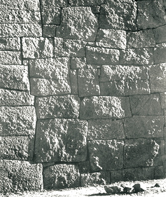
Fig. 7.1
A part of the stone wall that was
built around the city of Vijayanagara
1. The Discovery of Hampi
The ruins at Hampi were brought to light in 1800 by an engineer and antiquarian named Colonel Colin Mackenzie. An employee of the English East India Company, he prepared the first survey map of the site. Much of the initial information he received was based on the memories of priests of the Virupaksha temple and the shrine of Pampadevi. Subsequently, from 1856, photographers began to record the monuments which enabled scholars to study them. As early as 1836 epigraphists began collecting several dozen inscriptions found at this and other temples at Hampi. In an effort to reconstruct the history of the city and the empire, historians collated information from these sources with accounts of foreign travellers and other literature written in Telugu, Kannada, Tamil and Sanskrit.
Source 1
Colin Mackenzie
Born in 1754, Colin Mackenzie became famous as an engineer, surveyor and cartographer. In 1815 he was appointed the first Surveyor General of India, a post he held till his death in 1821. He embarked on collecting local histories and surveying historic sites in order to better understand India’s past and make governance of the colony easier. He says that “it struggled long under the miseries of bad management … before the South came under the benign influence of the British government”. By studying Vijayanagara, Mackenzie believed that the East India Company could gain “much useful information on many of these institutions, laws and customs whose influence still prevails among the various Tribes of Natives forming the general mass of the population to this day”.
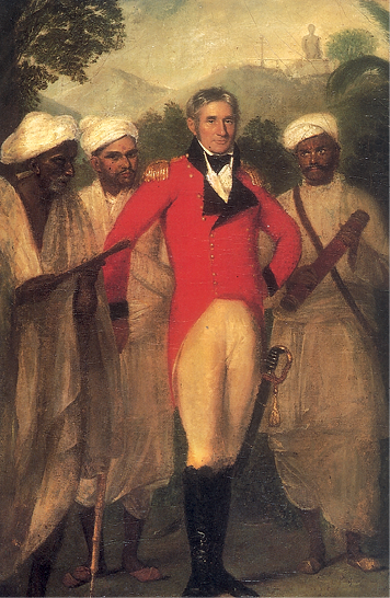
Fig. 7.2
Mackenzie and his assistants
This is a copy by an unknown artist of an oil painting by the portrait painter Thomas Hickey.
It dates to c.1825 and belongs to the collection of the Royal Asiatic Society of Britain and Ireland. On Mackenzie’s left is his peon Kistnaji holding
a telescope, on his right are Brahmana assistants –
a Jaina pandit (right) and behind him the Telugu Brahmana Cauvellery
Ventak Letchmiah.
How has the artist portrayed Mackenzie and his indigenous informers? What ideas about him and his informants are sought to be impressed upon the viewers?
2. Rayas, Nayakas and Sultans
According to tradition and epigraphic evidence two brothers, Harihara and Bukka, founded the Vijayanagara Empire in 1336. This empire included within its fluctuating frontiers peoples who spoke different languages and followed different religious traditions.
On their northern frontier, the Vijayanagara kings competed with contemporary rulers – including the Sultans of the Deccan and the Gajapati rulers of Orissa – for control of the fertile river valleys and the resources generated by lucrative overseas trade. At the same time, interaction between these states led to sharing of ideas, especially in the field of architecture. The rulers of Vijayanagara borrowed concepts and building techniques which they then developed further.
Karnataka samrajyamu
While historians use the term Vijayanagara Empire, contemporaries described it as the karnataka samrajyamu.
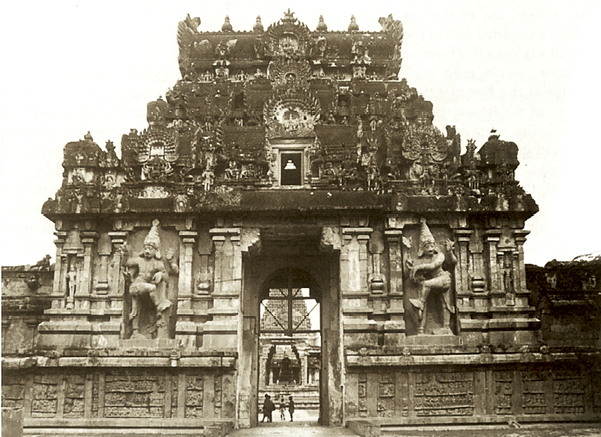
Fig. 7.3
The gopuram or gateway of the Brihadishvara temple at Thanjavur
Some of the areas that were incorporated within the empire had witnessed the development of powerful states such as those of the Cholas in Tamil Nadu and the Hoysalas in Karnataka. Ruling elites in these areas had extended patronage to elaborate temples such as the Brihadishvara temple at Thanjavur and the Chennakeshava temple at Belur. The rulers of Vijayanagara, who called themselves rayas, built on these traditions and carried them, as we will see, literally to new heights.
Elephants, horses and men
Gajapati literally means lord of elephants. This was the name of a ruling lineage that was very powerful in Orissa in the fifteenth century. In the popular traditions of Vijayanagara the Deccan Sultans are termed as ashvapati or lord of horses and the rayas are called narapati or lord of men.
2.1 Kings and traders
As warfare during these times depended upon effective cavalry, the import of horses from Arabia and Central Asia was very important for rival kingdoms. This trade was initially controlled by Arab traders. Local communities of merchants known as kudirai chettis or horse merchants also participated in these exchanges. From 1498 other actors appeared on the scene. These were the Portuguese, who arrived on the west coast of the subcontinent and attempted to establish trading and military stations. Their superior military technology, especially the use of muskets, enabled them to become important players in the tangled politics of the period.
In fact, Vijayanagara was also noted for its markets dealing in spices, textiles and precious stones. Trade was often regarded as a status symbol for such cities, which boasted of a wealthy population that demanded high-value exotic goods, especially precious stones and jewellery. The revenue derived from trade in turn contributed significantly to the prosperity of the state.
2.2 The apogee and decline of the empire
Within the polity, claimants to power included members of the ruling lineage as well as military commanders. The first dynasty, known as the Sangama dynasty, exercised control till 1485. They were supplanted by the Saluvas, military commanders, who remained in power till 1503 when they were replaced by the Tuluvas. Krishnadeva Raya belonged to the Tuluva dynasty.
Krishnadeva Raya’s rule was characterised by expansion and consolidation. This was the time when the land between the Tungabhadra and Krishna rivers (the Raichur doab) was acquired (1512), the rulers of Orissa were subdued (1514) and severe defeats were inflicted on the Sultan of Bijapur (1520). Although the kingdom remained in a constant state of military preparedness, it flourished under conditions of unparalleled peace and prosperity. Krishnadeva Raya is credited with building some fine temples and adding impressive gopurams to many important south Indian temples. He also founded a suburban township near Vijayanagara called Nagalapuram after his mother. Some of the most detailed descriptions of Vijayanagara come from his time or just after.
Source 2
Kings and traders
Krishnadeva Raya (ruled 1509-29), the most famous ruler of Vijayanagara, composed a work on statecraft in Telugu known as the Amuktamalyada. About traders he wrote:
A king should improve the harbours of his country and so encourage its commerce that horses, elephants, precious gems, sandalwood, pearls and other articles are freely imported … He should arrange that the foreign sailors who land in his country on account of storms, illness and exhaustion are looked after in a suitable manner … Make the merchants of distant foreign countries who import elephants and good horses be attached to yourself by providing them with daily audience, presents and allowing decent profits. Then those articles will never go to your enemies.
Why do you think the king was interested in encouraging trade? Which groups of people would have benefited from these transactions?
Strain began to show within the imperial structure following Krishnadeva Raya’s death in 1529. His successors were troubled by rebellious nayakas or military chiefs. By 1542 control at the centre had shifted to another ruling lineage, that of the Aravidu, which remained in power till the end of the seventeenth century. During this period, as indeed earlier, the military ambitions of the rulers of Vijayanagara as well as those of the Deccan Sultanates resulted in shifting alignments. Eventually this led to an alliance of the Sultanates against Vijayanagara. In 1565 Rama Raya, the chief minister of Vijayanagara, led the army into battle at Rakshasi-Tangadi (also known as Talikota), where his forces were routed by the combined armies of Bijapur, Ahmadnagar and Golconda. The victorious armies sacked the city of Vijayanagara. The city was totally abandoned within a few years. Now the focus of the empire shifted to the east where the Aravidu dynasty ruled from Penukonda and later from Chandragiri (near Tirupati).
Although the armies of the Sultans were responsible for the destruction of the city of Vijayanagara, relations between the Sultans and the rayas were not always or inevitably hostile, in spite of religious differences. Krishnadeva Raya, for example, supported some claimants to power in the Sultanates and took pride in the title “establisher of the Yavana kingdom”. Similarly, the Sultan of Bijapur intervened to resolve succession disputes in Vijayanagara following the death of Krishnadeva Raya. In fact the Vijayanagara kings were keen to ensure the stability of the Sultanates and vice versa. It was the adventurous policy of Rama Raya who tried to play off one Sultan against another that led the Sultans to combine together and decisively defeat him.
Yavana is a Sanskrit word used for the Greeks and other peoples who entered the subcontinent from the north west.
2.3 The rayas and the nayakas
Among those who exercised power in the empire were military chiefs who usually controlled forts and had armed supporters. These chiefs often moved from one area to another, and in many cases were accompanied by peasants looking for fertile land on which to settle. These chiefs were known as nayakas and they usually spoke Telugu or Kannada. Many nayakas submitted to the authority of the kings of Vijayanagara but they often rebelled and had to be subdued by military action.
The amara-nayaka system was a major political innovation of the Vijayanagara Empire. It is likely that many features of this system were derived from the iqta system of the Delhi Sultanate.
The amara-nayakas were military commanders who were given territories to govern by the raya. They collected taxes and other dues from peasants, craftspersons and traders in the area. They retained part of the revenue for personal use and for maintaining a stipulated contingent of horses and elephants. These contingents provided the Vijayanagara kings with an effective fighting force with which they brought the entire southern peninsula under their control. Some of the revenue was also used for the maintenance of temples and irrigation works.
The amara-nayakas sent tribute to the king annually and personally appeared in the royal court with gifts to express their loyalty. Kings occasionally asserted their control over them by transferring them from one place to another. However, during the course of the seventeenth century, many of these nayakas established independent kingdoms. This hastened the collapse of the central imperial structure.
Amara is believed to be derived from the Sanskrit word samara, meaning battle or war. It also resembles the Persian term amir, meaning a high noble.
Discuss...
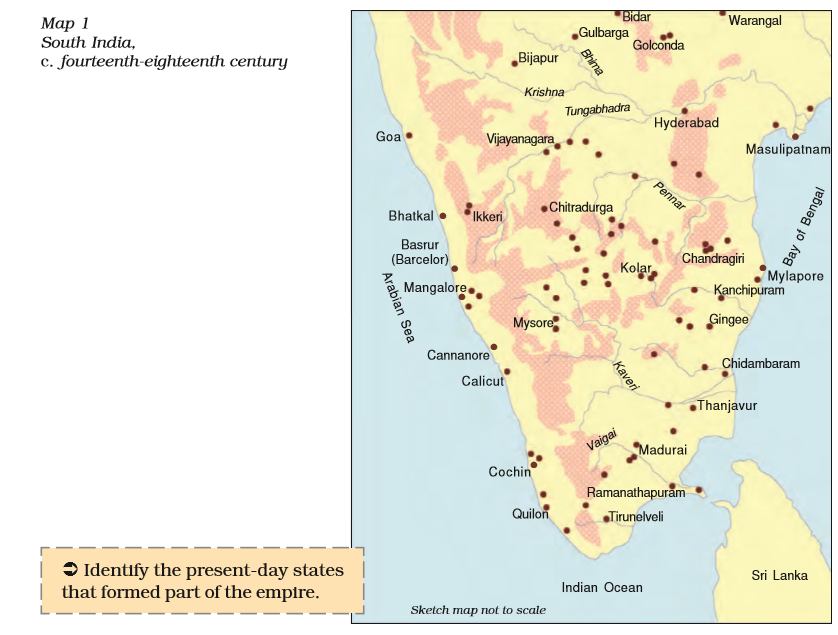
Locate Chandragiri, Madurai, Ikkeri, Thanjavur and Mysore, all centres of nayaka power, on Map 1. Discuss the ways in which rivers and hills may have facilitated or hindered communication with Vijayanagara in each case.
3. Vijayanagara The Capital and its Environs
Like most capitals, Vijayanagara, was characterised by a distinctive physical layout and building style.
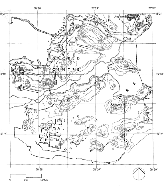
Fig. 7.4
Plan of Vijayanagara
Identify three major zones on the plan. Look at the central part.Can you see channels connectingup with the river? See how many fortification walls you can trace.Was the sacred centre fortified?
Finding out about the city
A large number of inscriptions of the kings of Vijayanagara and their nayakas recording donations to temples as well as describing important events have been recovered. Several travellers visited the city and wrote about it. Notable among their accounts are those of an Italian trader named Nicolo de Conti, an ambassador named Abdur Razzaq sent by the ruler of Persia, a merchant named Afanasii Nikitin from Russia, all of whom visited the city in the fifteenth century, and those of Duarte Barbosa, Domingo Paes and Fernao Nuniz from Portugal, who came in the sixteenth century.
A sprawling city
This is an excerpt from Domingo Paes’s description of Vijayanagara: The size of this city I do not write here, because it cannot all be seen from any one spot, but I climbed a hill whence I could see a great part of it; I could not see it all because it lies between several ranges of hills. What I saw from thence seemed to me as large as Rome, and very beautiful to the sight; there are many groves of trees within it, in the gardens of the houses, and many conduits of water which flow into the midst of it, and in places there are lakes; and the king has close to his palace a palm-grove and other rich fruit-bearing trees.
3.1 Water resources
The most striking feature about the location of Vijayanagara is the natural basin formed by the river Tungabhadra which flows in a north-easterly direction. The surrounding landscape is characterised by stunning granite hills that seem to form a girdle around the city. A number of streams flow down to the river from these rocky outcrops.
In almost all cases embankments were built along these streams to create reservoirs of varying sizes. As this is one of the most arid zones of the peninsula, elaborate arrangements had to be made to store rainwater and conduct it to the city. The most important such tank was built in the early years of the fifteenth century and is now called Kamalapuram tank. Water from this tank not only irrigated fields nearby but was also conducted through a channel to the “royal centre”.
One of the most prominent waterworks to be seen among the ruins is the Hiriya canal. This canal drew water from a dam across the Tungabhadra and irrigated the cultivated valley that separated the “sacred centre” from the “urban core”. This was apparently built by kings of the Sangama dynasty.
Source 4
How tanks were built
About a tank constructed by Krishnadeva Raya, Paes wrote:
The king made a tank … at the mouth of two hills so that all the water which comes from either one side or the other collects there; and, besides this, water comes to it from more than three leagues (approximately 15 kilometres) by pipes which run along the lower parts of the range outside. This water is brought from a lake which itself overflows into a little river. The tank has three large pillars handsomely carved with figures; these connect above with certain pipes by which they get water when they have to irrigate their gardens and rice-fields. In order to make this tank the said king broke down a hill … In the tank I saw so many people at work that there must have been fifteen or twenty thousand men, looking like ants …
3.2 Fortifications and roads
Before we examine the different parts of the city in detail let us look at what enclosed them all – the great fortress walls. Abdur Razzaq, an ambassador sent by the ruler of Persia to Calicut (present-day Kozhikode) in the fifteenth century, was greatly impressed by the fortifications, and mentioned seven lines of forts. These encircled not only the city but also its agricultural hinterland and forests. The outermost wall linked the hills surrounding the city. The massive masonry construction was slightly tapered. No mortar or cementing agent was employed anywhere in the construction. The stone blocks were wedge shaped, which held them in place, and the inner portion of the walls was of earth packed with rubble. Square or rectangular bastions projected outwards.
What was most significant about this fortification is that it enclosed agricultural tracts. Abdur Razzaq noted that“between the first, second and the third walls there are cultivated fields, gardens and houses”. And Paes observed: “From this first circuit until you enter the city there is a great distance, in which are fields in which they sow rice and have many gardens and much water, in which water comes from two lakes.” These statements have been corroborated by present-day archaeologists, who have also found evidence of an agricultural tract between the sacred centre and the urban core. This tract was serviced by an elaborate canal system drawing water from the Tungabhadra.
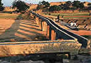
Fig. 7.5
An aqueduct leading into the royal centre
Describe the similarities and differences between these two entrances. Why do you think the rulers of Vijayanagara adopted elements of Indo-Islamic architecture?
Why do you think agricultural tracts were incorporated within the fortified area? Often, the objective of medieval sieges was to starve the defenders into submission. These sieges could last for several months and sometimes even years. Normally rulers tried to be prepared for such situations by building large granaries within fortified areas. The rulers of Vijayanagara adopted a more expensive and elaborate strategy of protecting the agricultural belt itself.
A second line of fortification went round the inner core of the urban complex, and a third line surrounded the royal centre, within which each set of major buildings was surrounded by its own high walls.
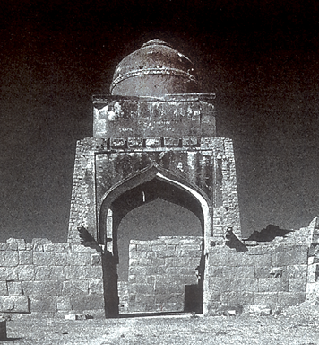
The fort was entered through well-guarded gates, which linked the city to the major roads. Gateways were distinctive architectural features that often defined the structures to which they regulated access. The arch on the gateway leading into the fortified settlement as well as the dome over the gate (Fig. 7.6) are regarded as typical features of the architecture introduced by the Turkish Sultans. Art historians refer to this style as Indo-Islamic, as it grew continually through interaction with local building practices in different regions.
Archaeologists have studied roads within the city and those leading out from it. These have been identified by tracing paths through gateways, as well as by finds of pavements. Roads generally wound around through the valleys, avoiding rocky terrain. Some of the most important roads extended from temple gateways, and were lined by bazaars.
3.3 The urban core
Moving along the roads leading into the urban core, there is relatively little archaeological evidence of the houses of ordinary people. Archaeologists have found fine Chinese porcelain in some areas, including in the north-eastern corner of the urban core and suggest that these areas may have been occupied by rich traders. This was also the Muslim residential quarter. Tombs and mosques located here have distinctive functions, yet their architecture resembles that of the mandapas found in the temples of Hampi.
This is how the sixteenth-century Portuguese traveller Barbosa described the houses of ordinary people, which have not survived: “The other houses of the people are thatched, but nonetheless well built and arranged according to occupations, in long streets with many open places.”
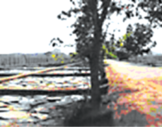
Fig. 7.8
Part of an excavated pavement
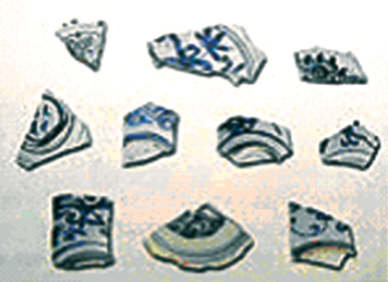
Fig. 7.9
Shards of Chinese porcelain
What kinds of vessels do you think these shards were originally parts of?
Field surveys indicate that the entire area was dotted with numerous shrines and small temples, pointing to the prevalence of a variety of cults, perhaps supported by different communities. The surveys also indicate that wells, rainwater tanks as well as temple tanks may have served as sources of water to the ordinary town dwellers.
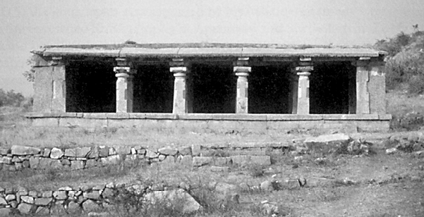
Fig. 7.10 A mosque in Vijayanagara
Does the mosque have the typical features of Indo-Islamic architecture?
4. The Royal Centre
The royal centre was located in the south-western part of the settlement. Although designated as a royal centre, it included over 60 temples. Clearly, the patronage of temples and cults was important for rulers who were trying to establish and legitimise their authority through association with the divinities housed in the shrines.
Discuss...
Compare the layout of Vijayanagara with that of your town or village.
About thirty building complexes have been identified as palaces. These are relatively large structures that do not seem to have been associated with ritual functions. One difference between these structures and temples is that the latter were constructed entirely of masonry, while the superstructure of the secular buildings was made of perishable materials.
A House of Victory?
This is what Paes had to say about the audience hall and the mahanavami dibba , which together he called the “House of Victory”:
These buildings have two platforms one above the other, beautifully sculpted … On the upper platform … in this House of Victory the king has a room made of cloth … where the idol has a shrine ... and in the other in the middle is placed a dais on which stands a throne of state, (the crown and the royal anklet) …
4.1 The mahanavami dibba
Some of the more distinctive structures in the area have been assigned names based on the form of the buildings as well as their functions. The “king’s palace” is the largest of the enclosures but has not yielded definitive evidence of being a royal residence. It has two of the most impressive platforms, usually called the “audience hall” and the “mahanavami dibba”. The entire complex is surrounded by high double walls with a street running between them. The audience hall is a high platform with slots for wooden pillars at close and regular intervals. It had a staircase going up to the second floor, which rested on these pillars. The pillars being closely spaced, would have left little free space and thus it is not clear what the hall was used for.
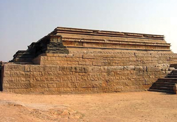
Fig. 7.11
The mahanavami dibba
Located on one of the highest points in the city, the “mahanavami dibba” is a massive platform rising from a base of about 11,000 sq. ft to a height of 40 ft. There is evidence that it supported a wooden structure. The base of the platform is covered with relief carvings (Fig. 7.12).
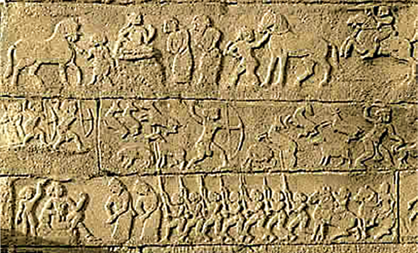
Fig. 7.12
Carvings on the mahanavami dibba
Can you identify the themes of the carvings?
Rituals associated with the structure probably coincided with Mahanavami (literally, the great ninth day) of the ten-day Hindu festival during the autumn months of September and October, known variously as Dusehra (northern India), Durga Puja (in Bengal) and Navaratri or Mahanavami (in peninsular India). The Vijayanagara kings displayed their prestige, power and suzerainty on this occasion.
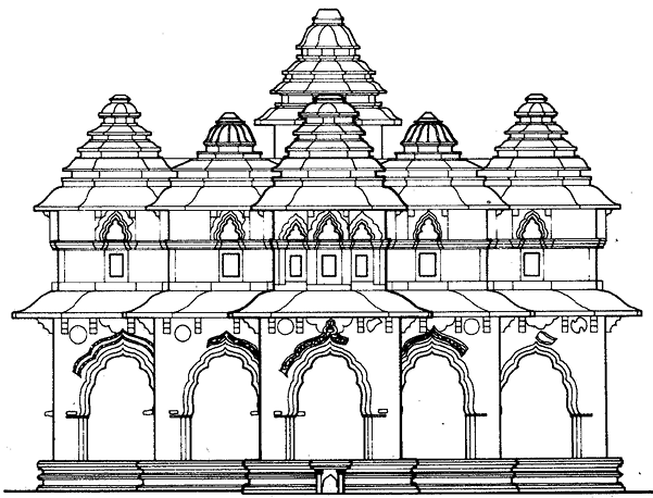
Fig. 7.13
An elevation drawing of the
Lotus Mahal
An elevation is a vertical view of any object or structure. It gives you an idea of features that cannot be seen in a photograph. Notice the arches. These were probably inspired by Indo-Islamic techniques.
Compare Figs. 7.13 and 7.15, and make a list of the features that are common to both, as well as those that can be seen in only one. Also compare the arch in Fig. 7.14 with the arch in Fig. 7.6. The Lotus Mahal had nine towers – a high central one, and eight along the sides. How many can you see in the photograph and how many in the elevation?
The ceremonies performed on the occasion included worship of the image, worship of the state horse, and the sacrifice of buffaloes and other animals. Dances, wrestling matches, and processions of caparisoned horses, elephants and chariots and soldiers, as well as ritual presentations before the king and his guests by the chief nayakas and subordinate kings marked the occasion. These ceremonies were imbued with deep symbolic meanings. On the last day of the festival the king inspected his army and the armies of the nayakas in a grand ceremony in an open field. On this occasion the nayakas brought rich gifts for the king as well as the stipulated tribute.
Was the “mahanavami dibba” that stands today the centre of this elaborate ritual? Scholars have pointed out that the space surrounding the structure does not seem to have been adequate for elaborate processions of armed men, women, and large numbers of animals. Like some of the other structures in the royal centre, it remains an enigma.
4.2 Other buildings in the royal centre
One of the most beautiful buildings in the royal centre is the Lotus Mahal, so named by British travellers in the nineteenth century. While the name is certainly romantic, historians are not quite sure what the building was used for. One suggestion, found in a map drawn by Mackenzie, is that it may have been a council chamber, a place where the king met his advisers.
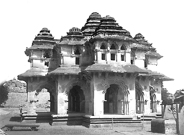
Fig. 7.15 A photograph of the Lotus Mahal
While most temples were located in the sacred centre, there were several in the royal centre as well.
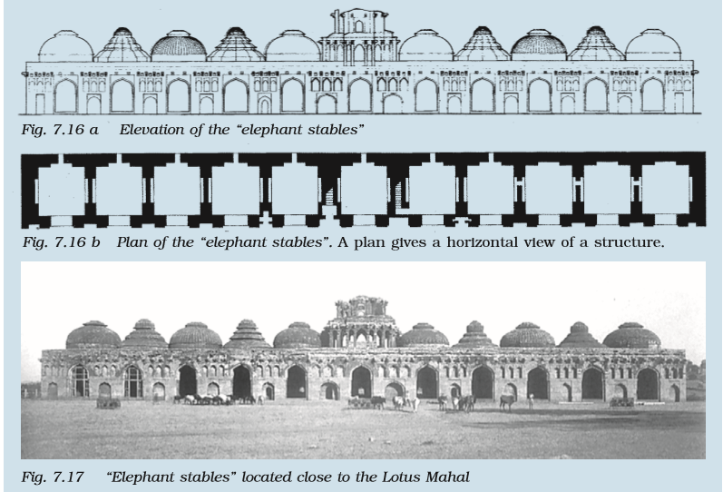
Compare Figs. 7.16 a and 7.16 b with Fig. 7.17, making a list of features visible in each one. Do you think these were actually elephant stables?
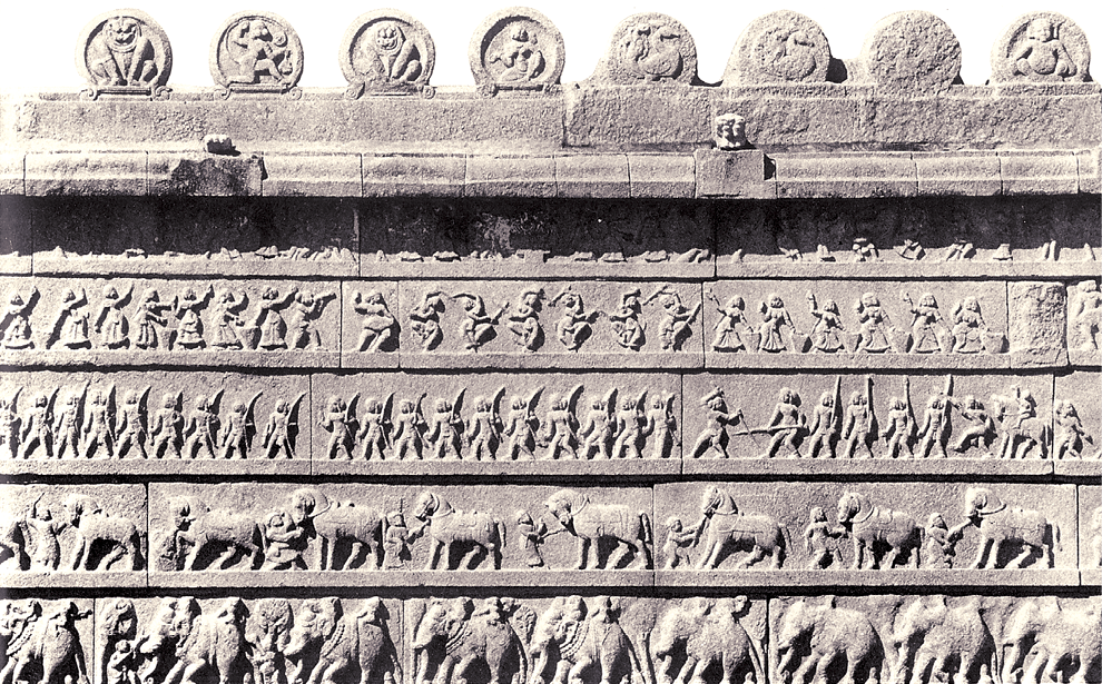
Fig. 7.18
Sculpture from the Hazara Rama temple
Can you identify scenes of dancing? Why do you think elephants and horses were depicted on the panels?
One of the most spectacular of these is one known as the Hazara Rama temple. This was probably meant to be used only by the king and his family. The images in the central shrine are missing; however, sculpted panels on the walls survive. These include scenes from the Ramayana sculpted on the inner walls of the shrine.
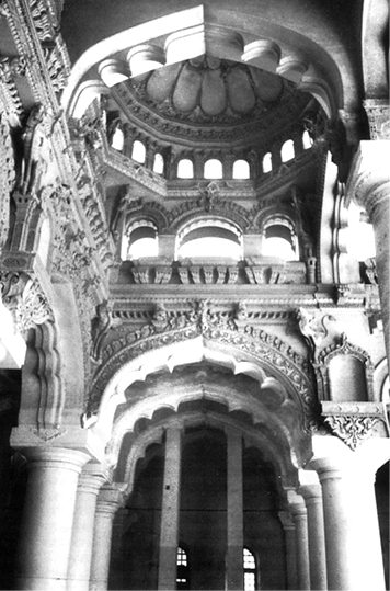
Fig. 7.19
Interior of the audience hall
at Madurai
Note the arches.
While many of the structures at Vijayanagara were destroyed when the city was sacked, traditions of building palatial structures were continued by the nayakas. Many of these buildings have survived.
Discuss...
Why did the nayakas continue with the building traditions of the rulers of Vijayanagara?
5. The Sacred Centre
5.1 Choosing a capital
We now move to the rocky northern end of the city on the banks of the Tungabhadra. According to local tradition, these hills sheltered the monkey kingdom of Vali and Sugriva mentioned in the Ramayana. Other traditions suggest that Pampadevi, the local mother goddess, did penance in these hills in order to marry Virupaksha, the guardian deity of the kingdom, also recognised as a form of Shiva. To this day this marriage is celebrated annually in the Virupaksha temple. Among these hills are found Jaina temples of the pre-Vijayanagara period as well. In other words, this area was associated with several sacred traditions.
Temple building in the region had a long history, going back to dynasties such as the Pallavas, Chalukyas, Hoysalas and Cholas. Rulers very often encouraged temple building as a means of associating themselves with the divine – often, the deity was explicitly or implicitly identified with the king. Temples also functioned as centres of learning. Besides, rulers and others often granted land and other resources for the maintenance of temples. Consequently, temples developed as significant religious, social, cultural and economic centres. From the point of view of the rulers, constructing, repairing and maintaining temples were important means of winning support and recognition for their power, wealth and piety.
It is likely that the very choice of the site of Vijayanagara was inspired by the existence of the shrines of Virupaksha and Pampadevi. In fact the Vijayanagara kings claimed to rule on behalf of the god Virupaksha. All royal orders were signed “Shri Virupaksha”, usually in the Kannada script. Rulers also indicated their close links with the gods by using the title “Hindu Suratrana”. This was a Sanskritisation of the Arabic term Sultan, meaning king, so it literally meant Hindu Sultan.
Even as they drew on earlier traditions, the rulers of Vijayanagara innovated and developed these. Royal portrait sculpture was now displayed in temples, and the king’s visits to temples were treated as important state occasions on which he was accompanied by the important nayakas of the empire.
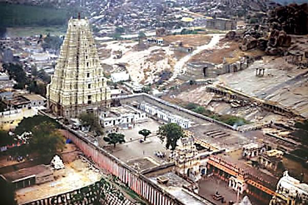
Fig. 7.20
An aerial view of the
Virupaksha temple
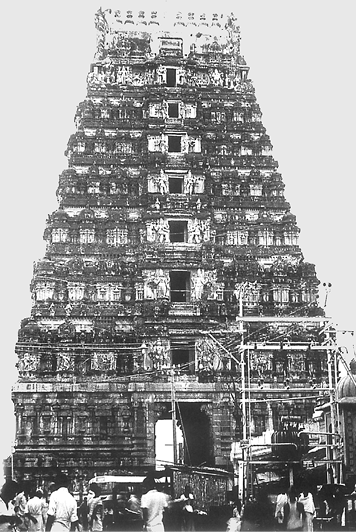
5.2. Gopurams and mandapas
In terms of temple architecture, by this period certain new features were in evidence. These included structures of immense scale that must have been a mark of imperial authority, best exemplified by the raya gopurams (Fig. 7.7) or royal gateways that often dwarfed the towers on the central shrines, and signalled the presence of the temple from a great distance. They were also probably meant as reminders of the power of kings, able to command the resources, techniques and skills needed to construct these towering gateways. Other distinctive features include mandapas or pavilions and long, pillared corridors that often ran around the shrines within the temple complex. Let us look at two temples more closely – the Virupaksha temple and the Vitthala temple.
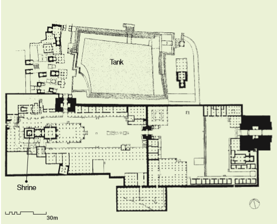
Fig. 7.21
A plan of the Virupaksha temple
Most of the square structures are shrines.
The two major gateways are shaded in black. Each tiny dot represents a pillar. Rows of pillars arranged in lines
within a square or rectangular frame appear to demarcate major halls, pavilions and corridors.
Using the scale in the plan, measure the distance from the main gopuram to the central shrine. What would have been the easiest access from the tank to the shrine?
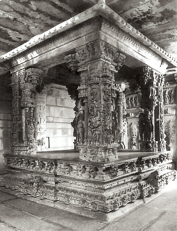
Fig. 7.22
A kalyana mandapa, meant to celebrate divine weddings
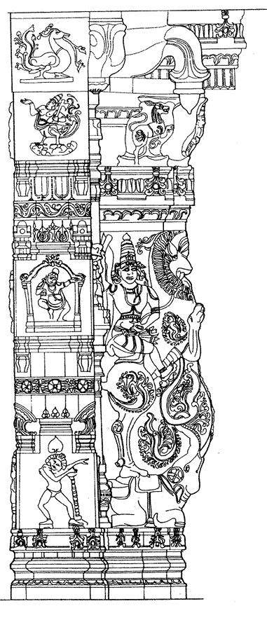
Fig. 7.23
A line drawing of a sculpted pillar
Describe what you see on the pillar.
The Virupaksha temple was built over centuries. While inscriptions suggest that the earliest shrine dated to the ninth-tenth centuries, it was substantially enlarged with the establishment of the Vijayanagara Empire. The hall in front of the main shrine was built by Krishnadeva Raya to mark his accession. This was decorated with delicately carved pillars. He is also credited with the construction of the eastern gopuram. These additions meant that the central shrine came to occupy a relatively small part of the complex.
The halls in the temple were used for a variety of purposes. Some were spaces in which the images of gods were placed to witness special programmes of music, dance, drama, etc. Others were used to celebrate the marriages of deities, and yet others were meant for the deities to swing in. Special images, distinct from those kept in the small central shrine, were used on these occasions.
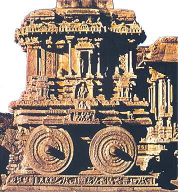
Fig. 7.24
The chariot of the Vitthala temple
Do you think chariots would have actually been built like this?
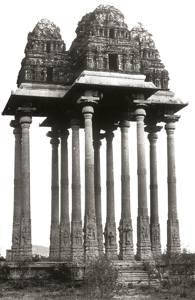
Fig. 7.25
Swing pavilion from Gingee
Another shrine, the Vitthala temple, is also interesting. Here, the principal deity was Vitthala, a form of Vishnu generally worshipped in Maharashtra. The introduction of the worship of the deity in Karnataka is another indication of the ways in which the rulers of Vijayanagara drew on different traditions to create an imperial culture. As in the case of other temples, this temple too has several halls and a unique shrine designed as a chariot (Fig. 7.24).
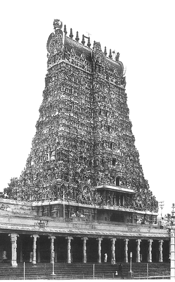
Fig. 7.26
A gopuram built by the nayakas of Madurai
A characteristic feature of the temple complexes is the chariot streets that extended from the temple gopuram in a straight line. These streets were paved with stone slabs and lined with pillared pavilions in which merchants set up their shops.
Just as the nayakas continued with and elaborated on traditions of fortification, so they did with traditions of temple building. In fact, some of the most spectacular gopurams were also built by the local nayakas.
Discuss...
How and why did the rulers of Vijayanagara adopt and adapt earlier traditions of ritual architecture?
6. Plotting Palaces, Temples and Bazaars
We have been examining a wealth of information on Vijayanagara – photographs, plans, elevations of structures and sculpture. How was all of this produced? After the initial surveys by Mackenzie, information was pieced together from travellers’ accounts and inscriptions. Through the twentieth century, the site was preserved by the Archaeological Survey of India and the Karnataka Department of Archaeology and Museums. In 1976, Hampi was recognised as a site of national importance. Then, in the early 1980s, an important project was launched to document the material remains at Vijayanagara in detail, through extensive and intensive surveys, using a variety of recording techniques. Over nearly twenty years, dozens of scholars from all over the world worked to compile and preserve this information.
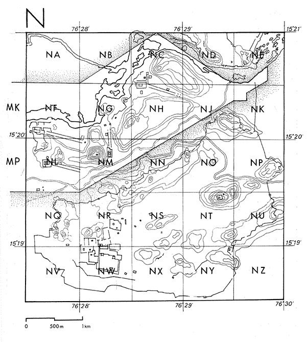
Fig. 7.27
A detailed map of the site (top right)
Which is the letter of the alphabet that was not used? Using the scale in the map, measure the length of any one of the small squares.
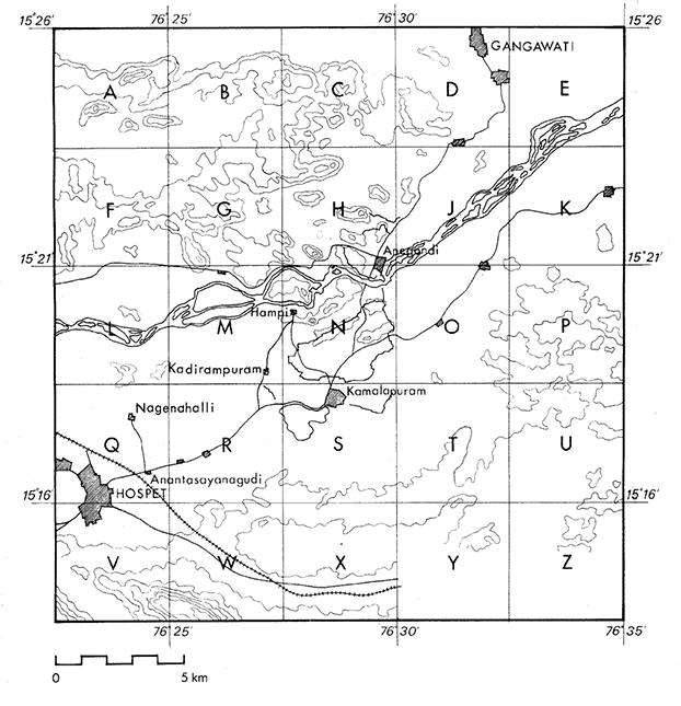
Fig. 7.28
Square N of Fig. 7.27 (right)
What is the scale used on this map?
Let us look at just one part of this enormous exercise – mapping – in more detail. The first step was to divide the entire area into a set of 25 squares, each designated by a letter of the alphabet. Then, each of the small squares was subdivided into a set of even smaller squares. But this was not all: each of these smaller squares was further subdivided into yet smaller units.
As you can see, these detailed surveys have been extremely painstaking, and have recovered and documented traces of thousands of structures – from tiny shrines and residences to elaborate temples. They have also led to the recovery of traces of roads, paths, bazaars, etc. The latter have been located through finds of pillar bases and platforms – all that remain of thriving markets.
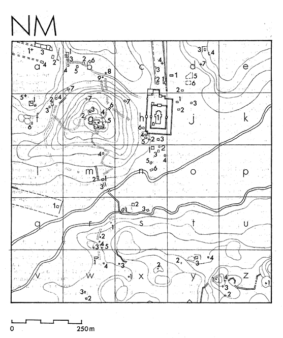
Fig. 7.29
Square NM of Fig. 7.28
Identify a temple. Look for walls, a central shrine, and traces of paths leading to the temple. Name the squares on the map which contain the plan of the temple.
It is worth remembering something that John M. Fritz, George Michell and M.S. Nagaraja Rao, who worked for years at the site, wrote: “In our study of these monuments of Vijayanagara we have to imagine a whole series of vanished wooden elements – columns, brackets, beams, ceilings, overhanging eaves, and towers – decorated with plaster and painted, perhaps brightly.”
Although wooden structures are lost, and only stone structures survive, the descriptions left by travellers allow us to reconstruct some aspects of the vibrant life of the times.
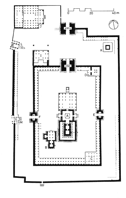
Fig. 7.30
Plan of the temple in Fig 7.29
Identify the gopuram, halls, colonnades and central shrine. Which areas would you pass through to reach the central shrine from the outer entrance?
The bazaar
Paes gives a vivid description of the bazaar:
Going forward, you have a broad and beautiful street … In this street live many merchants, and there you will find all sorts of rubies, and diamonds, and emeralds, and pearls, and seed-pearls, and cloths, and every other sort of thing there is on earth and that you may wish to buy. Then you have there every evening a fair where they sell many common horses and nags, and also many citrons, and limes, and oranges, and grapes, and every other kind of garden stuff, and wood; you have all in this street.
More generally, he described the city as being “the best-provided city in the world” with the markets “stocked with provisions such as rice, wheat, grains, India corn and a certain amount of barley and beans, moong, pulses and horse-gram” all of which were cheaply and abundantly available. According to Fernao Nuniz, the Vijayanagara markets were “overflowing with abundance of fruits, grapes and oranges, limes, pomegranates, jackfruit and mangoes and all very cheap”. Meat too was sold in abundance in the marketplaces. Nuniz describes “mutton, pork, venison, partridges, hares, doves, quail and all kinds of birds, sparrows, rats and cats and lizards” as being sold in the market of Bisnaga (Vijayanagara).
7. Questions in Search of Answers
Buildings that survive tell us about the way spaces were organised and used, how they were built, with what materials and techniques. For example, we can assess the defence requirements and military preparedness of a city by studying its fortifications. Buildings also tell us about the spread of ideas and cultural influences if we compare them with buildings in other places. They convey ideas which the builders or their patrons wished to project. They are often suffused with symbols which are a product of their cultural context. These we can understand when we combine information from other sources like literature, inscriptions and popular traditions.
Investigations of architectural features do not tell us what ordinary men, women and children, comprising the vast majority of the people who lived in the city and its outskirts, thought about these impressive buildings. Would they have had access to any of the areas within the royal centre or the sacred centre? Would they hurry past the sculpture, or would they pause to see, reflect and try and understand its complicated symbolism? And what did the people who worked on these colossal construction projects think of the enterprises to which they had contributed their labour?
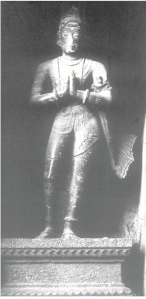
Krishnadeva Raya
To recapitulate about some of the problems of perspective, look at this beautiful statue of Krishnadeva Raya placed on the gopuram of the temple at Chidambaram, Tamil Nadu. This is obviously the way in which the ruler wanted to project himself. And this is how Paes describes the king:
Of medium height, and of fair complexion and good figure, rather fat than thin; he has on his face signs of smallpox.
While rulers took all important decisions about the buildings to be constructed, the site, the material to be used and the style to be followed, who possessed the specialised knowledge required for such enormous enterprises? Who drew up the plans for the buildings? Where did the masons, stonecutters, sculptors who did the actual building come from? Were they captured during war from neighbouring regions? What kind of wages did they get? Who supervised the building activity? How was building material transported and where did it come from? These are some of the questions that we cannot answer by merely looking at the buildings or their remains. Continuing research using other sources might provide some further clues.
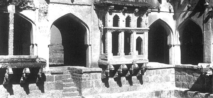
Fig. 7.32
Part of a structure known as the queen’s bath
Answer in100-150 words
1. What have been the methods used to study the ruins of Hampi over the last two centuries? In what way do you think they would have complemented the information provided by the priests of the Virupaksha temple?
2. How were the water requirements of Vijayanagara met?
3. What do you think were the advantages and disadvantages of enclosing agricultural land within the fortified area of the city?
4. What do you think was the significance of the rituals associated with the mahanavami dibba?
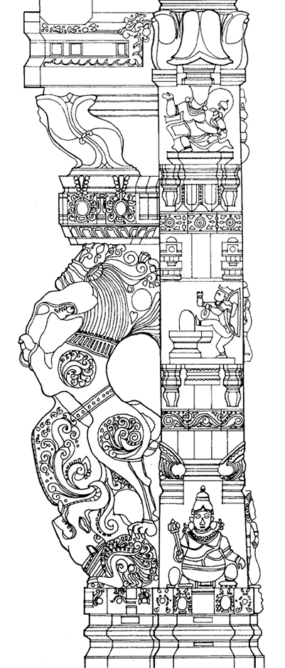
5. Fig. 7.33 is an illustration of another pillar from the Virupaksha temple. Do you notice any floral motifs? What are the animals shown? Why do you think they are depicted? Describe the human figures shown.
Write a short essay (about 250-300 words) on the following:
6. Discuss whether the term “royal centre” is an appropriate description for the part of the city for which it is used.
7. What does the architecture of buildings like the Lotus Mahal and elephant stables tell us about the rulers who commissioned them?
8. What are the architectural traditions that inspired the architects of Vijayanagara? How did they transform these traditions?
9. What impression of the lives of the ordinary people of Vijayanagara can you cull from the various descriptions in the chapter?
Map work
10. On an outline map of the world, mark approximately Italy, Portugal, Iran and Russia. Trace the routes the travellers mentioned on p.176 would have taken to reach Vijayanagara.
Project (choose one)
11. Find out more about any one of the major cities which flourished in the subcontinent during c. fourteenth-seventeenth centuries. Describe the architecture of the city. Are there any features to suggest that these were political centres? Are there buildings that were ritually significant? Is there an area for commercial activities? What are the features that distinguish the urban layout from that of surrounding areas?
12. Visit a religious building in your neighbourhood. Describe, with sketches, its roof, pillars and arches if any, corridors, passages, halls, entrance, water supply, etc. Compare these features with those of the Virupaksha temple. Describe what each part of the building is used for. Find out about its history.
If you would like to know more, read:
Vasundhara Filliozat. 2006 (rpt).
Vijayanagara.
National Book Trust,
New Delhi.
George Michell. 1995.
Architecture and Art of Southern India.
Cambridge University Press, Cambridge.
K.A. Nilakanta Sastri. 1955.
A History of South India.
Oxford University Press,
New Delhi.
Burton Stein. 1989. Vijayanagara (The New Cambridge History of India Vol.1, Part 2).
Foundation Books, New Delhi.